

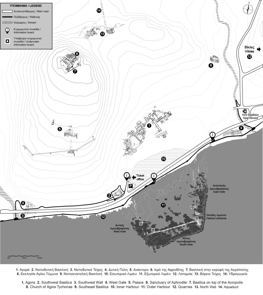
Amathus is built at a privileged location that facilitated the active involvement of its inhabitants in international seaborne trade networks. The earliest testimonies of overseas contacts may be seen on finds dating to the Early Iron Age (10th century BCΕ). A significant number of clay ship models, found in tombs and in the sea, attest to an increased maritime activity at the town, at least during the Archaic period (7th to 6th centuries BCE). The long history of Amathus is also attested by the many monuments of different chronological periods, present at the site: the ancient Agora, now situated inside the archaeological park, the Acropolis, fortified in antiquity, with a monumental structure on the slope that has been identified as the palace of Amathus. On the top of the hill, two cult places were excavated: the sanctuary of Aphrodite and the early Christian Basilica of the Acropolis.
A natural cove southeast of the ancient Agora which continued below the modern coastal road, was probably used as the town’s first harbour. Today, that inner harbour is ‘invisible’ since gradual silting during the 3rd to 1st centuries BCE, led to the progradation of the coast towards the sea. The outer harbour of Amathus is dated to the beginning of the Hellenistic period (end of the 4th century BCE).
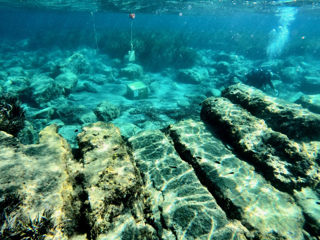
Contrary to what is often the case at other ancient harbour sites in the Mediterranean, the harbour of Amathus is preserved in its original form, without any disturbance from later use. This was demonstrated by an underwater excavation conducted by the French School at Athens during the 1980s. It was one of the first harbour excavations in the eastern Mediterranean and brought to light important aspects of the history of this enigmatic underwater monument. The exposed features of the harbour attest to a work of significant financial investment, comprehensive planning and technical knowledge. Climatic changes, natural phenomena and human interventions modified the geomorphology of the coastal zone, which resulted in the harbour being completely submerged today, at a depth ranging from 1 to 4 metres.
As life in Amathus continued until Late Antiquity (5th to7th centuries CE), the harbour was probably used for small-scale maritime activities. Following the Arab raids in the mid-7th century CE, Amathus was gradually abandoned and the urban centre was transferred farther west, to Theodosias/ Neapolis/ Nemesos (later Lemesos).
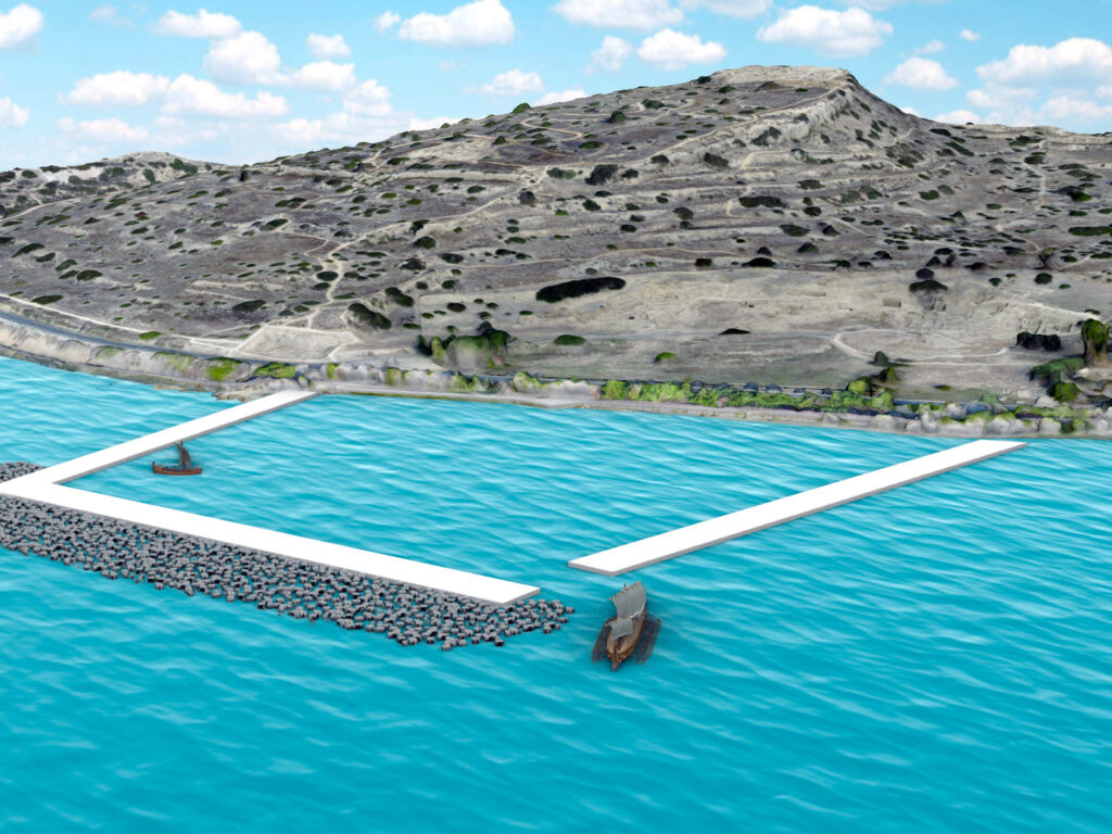
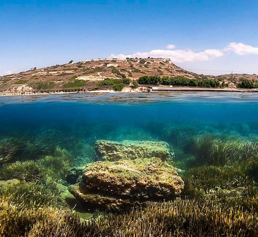
The MARELab in collaboration with the Department of Antiquities, Cyprus, and the Department of Fisheries and Marine Research, embarked on the ANDIKAT project to create the first underwater archaeological park in Cyprus. The harbour of Amathus was selected for a number of reasons. First, since its abandonment in antiquity, it has been preserved in its original phase, with no disturbance from later use. Second, the architectural remains are situated in shallow waters and close to the shore, allowing for easy public access. Third, the unique biodiversity of the site, which had led to the decision to include the harbour in the Marine Protected Area of Amathus, added to the significance of the site.
Acknowledging that the cultural and natural heritage constitute an integral part of the unique underwater landscape of Amathus, the permanent intrusions made by the ANDIKAT project were minimal, and serve as an open invitation to different public groups to visit the ancient harbour and its surroundings. Three information boards, one at the entrance of the Amathus archaeological site and two along the coastal walkway, provide information for pedestrians, while four underwater information boards act as orientation points for swimmers.


Download the App:


Since this is an open-access site, emphasis was given to personalised visits. Toward that end, the application “Amathus Harbour” was created for smart mobile devices. Remote navigation is possible through an interactive map that provides information complemented by audiovisual media. While on site, the application shows the geographical location of the visitor, indicating the points of interest nearby. Users can also enhance their visit by activating the audio guided tour. Walking along the coast and listening to or reading about the history and the environment of this unique landscape, visitors may create their own trails, before they swim to have a closer look at the remains of the ancient harbour of Amathus.
The Amathus DMA provides an engaging exploration of the dynamic relationship between human activity and the coastal landscape, by showcasing a sequence of four distinct phases of the site’s history. Beginning with Phase 1, the Amathus’s first, natural harbour is highlighted, before users move on to Phase 2 where they are informed of the intricacies of the construction of the outer, artificial harbour and the historical context behind its creation. In Phase 3, the application focuses on the period following the abandonment of the outer harbour, offering insights into sea-level and coastal changes and how these transformed the site. Finally, Phase 4 presents the current state of the site and how the enclosed area of the ancient harbour created favourable conditions for the development of remarkable biodiversity.
Software
The photogrammetric models were processed using Agisoft Metashape. The 3D scene and exported .gltf file were created using Autodesk Maya and the Verge 3D plugin. Verge 3D and Adobe Dreamweaver were then used in tandem to create the final interactive application.
Given Verge3D’s reliance on WebGL for rendering 3D graphics within web browsers, we highly recommend using Google Chrome for the best viewing experience when interacting with Mare Cyprium’s 3D web applications.
Acknowledgements
Photogrammetric documentation: Photogrammetric Vision Lab of the Cyprus University of Technology.
3D models of an Athenian Triereme and of the Kyrenia ship © 2018 iMARECULTURE project.
Further reading
Empereur, J.-Y., and Koželj, T. (Εds.) (2017). The Hellenistic Harbour of Amathus. Underwater Excavations 1984-1986. Volume 1: Architecture and History. Paris: École Française d’Athènes.
Empereur, J.-Y. (Ed.) (2018). The Hellenistic Harbour of Amathus. Underwater Excavations 1984-1986. Volume 2: Artefacts found during excavation. Paris: École Française d’Athènes.